

How to Calculate Time Using the Concepts of Geography?
Time is considered to be one of the prime or fundamental physical quantities. It is a concept we use to calculate seconds, minutes, hours, days, months, and years for our convenience. Tracking time enables us to comprehend our various activities. We can also measure the differences in time in various locations considering the geographical longitudes.
Time calculation in Geography is a crucial topic we cover in the class curriculum. It is a way to determine the time and calibrate our days and nights. It not only adds convenience in realising the phase of days but also enables us to communicate with this concept. Let us find out what we mean by time and then learn how to calculate it.
What is Time?
Time is one of the core dimensions based on which we measure various other physical quantities. It is a concept that allows us to measure a moment or period. It means that time is a way to measure an interval or a period that physically does not exist.
It can also be considered as a reference frame to find out the different phases of days and nights. Based on the prevalent concepts, we can measure time using various units such as seconds, minutes, hours, etc.
We can also define the past, present, and future according to time. The current timeframe is called the present. Something that is happening before a proposed timeframe is called the past. Something that will happen after a proposed timeframe is called the future.
By using the above-mentioned concepts, we define how to calculate time. Our ancestors used sundials to measure time during the daytime using the position of shadows. At night, the location of stars and the moon also helped us measure time. Hourglasses and eventually clocks were invented to measure time.
The invention of clocks was based on the concept of measuring a second. It is an interval scientifically explained as the time elapsed during 9,192,631,770 cycles of radiation produced between two levels of a Cesium-133 atom. This is how the foundation of time is built scientifically. Adding this interval 60 times gives us a minute.
How to Calculate Time in Geography?
We have studied that the world is divided into zones with the help of imaginary lines called the longitudes and latitudes. Well, latitudes run from east to west. They are parallel to each other. Longitudes, on the other hand, run from one pole to the other. It means that all the longitudes will meet at the poles.
These longitudinal lines are considered Meridians. Meridians are used to calculate time zones. Now, the real question is whether we have to consider one longitude as the standard for the reference frame. In 1844, astronomers and other researchers from 25 different countries decided to frame a timeline called the Prime Meridian. It is also called Greenwich Meridian. The time in this meridian is called the Greenwich Mean Time (GMT).
This meridian marks the starting point of a day. It also means that the highest point of the sun on that longitude is called noon or midday. We know that the earth rotates from west to east. It means that the places on the eastern side of this meridian will be ahead of the places on the western side.
Time Zones and GMT
Also Read: Learn What is a Time Zone and How Many Exist
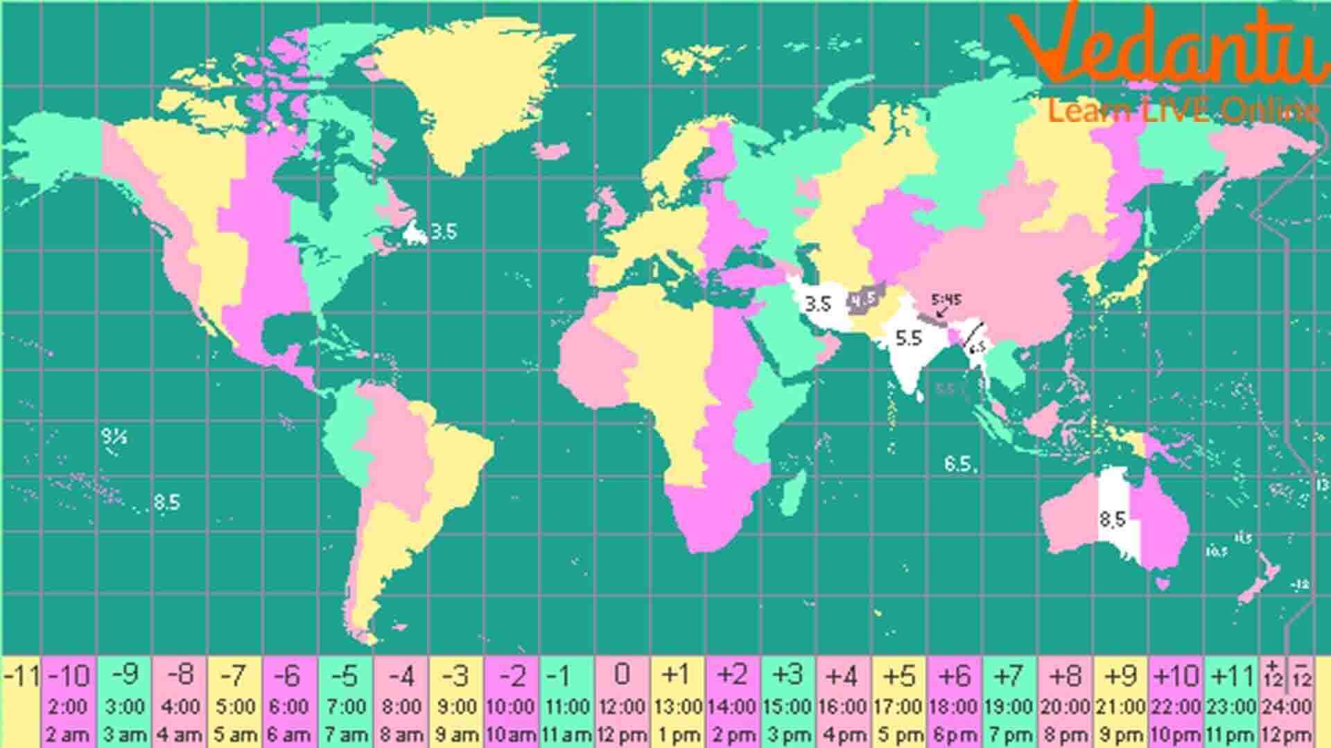
According to this concept, we consider a longitude and time calculation together to find out the right time of a place. The earth makes a full rotation in 24 hours. It means it covers 360° within that time period. If we calculate, we will find out that the earth takes 4 minutes to cover 1° and an hour to cover 15°.
Considering this calculation, the time zone 1 hour ahead of GMT is depicted as GMT + 1. This time zone will lie at 15° East of GMT. Similarly, the time zone 1 hour behind the GMT is depicted as GMT – 1. It will lie 15° West of GMT. So, when it is 12:00 PM in GMT, it is 1:00 PM in 15° E and 11:00 AM in 15° W. This is how we calculate time difference using the concepts of longitudes.
The Indian Standard Time (IST)
We have learned how to calculate latitude and longitude in the geography classes and have learned to calculate time using this concept. Let us consider our example. The Indian Standard Time (IST) is considered according to 82.5° E or 82° 30’ E Longitude.
We all know that India is the 7th largest country in terms of area. It is also called the Indian Subcontinent due to its huge size. Hence, it is obvious that the timeline will vary between the easternmost and westernmost corners of our country. To standardise it, we consider this longitude passing through Mirzapur in Uttar Pradesh as the standard to calculate local time.
From the above calculation, we can clearly understand that IST is 5 hours 30 minutes ahead of GMT. It means that the time in India is 5:30 PM while it is 12:00 PM in GMT.
Removing Date Confusion
If we look closely, we will find out that New Zealand and the Philippines are on the opposite side of the GMT. It means they are halfway between the time differences according to the Prime Meridian. To overcome this confusion, an international date line is considered 180° from Prime Meridian. Crossing this line will add or reduce one day.
This is how time is calculated considering the meridians and the Prime Meridian (0°). The concept is quite fascinating. We can now easily find the time difference and calculate the time of a specific longitude on the globe.


