


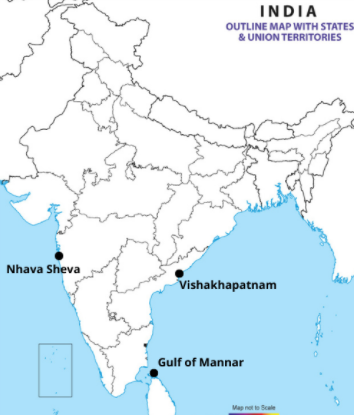
Draw an outline map of India and locate the following places.
1. Gulf of mannar
2. Visakhapatnam
3. Nhava sheva
Answer
526.8k+ views
Hint: A port is a ship landing point on the ocean coast, a river, or a lake. To load and unload their cargo and passengers, ships dock at ports. In the transportation of goods and raw materials, ports play a crucial role. A gulf is a part of a land-penetrating ocean. Gulfs differ dramatically in scale, form, and depth. Generally, they are wider than bays and more deeply indented.
Complete answer:
1. Gulf of mannar: The Mannar Gulf, an inlet of the Indian Ocean, between western Sri Lanka and southeastern India. Rameswaram (island), Adam's (Rama's) Bridge (a chain of shoals), and Mannar Island are limited to the northeast.
2. Visakhapatnam: The port of Visakhapatnam is one of India's 13 major ports and the only major port in Andhra Pradesh. By volume of cargo handled, it is India's third largest state-owned port and the largest on the Eastern Coast.
3. Nhava sheva: The largest container port in India is the Jawaharlal Nehru Port, also known as the Nhava Sheva port. JNPT handles the bulk of India's containerized trade east of Mumbai, in the state of Maharashtra, and is the focal point of long-haul calls to and from the emerging market economy.
Note: Based on freight throughput, the Port of Shanghai is the world's largest port. In 2012, the Chinese port handled 744 million tonnes of freight, including 32.5 million 20-foot container equivalent units (TEUs). The port is situated at the mouth of an area of 3,619km2 covering the Yangtze River.
Recently Updated Pages
Master Class 10 Computer Science: Engaging Questions & Answers for Success
Master Class 10 General Knowledge: Engaging Questions & Answers for Success
Master Class 10 English: Engaging Questions & Answers for Success
Master Class 10 Social Science: Engaging Questions & Answers for Success
Master Class 10 Maths: Engaging Questions & Answers for Success
Master Class 10 Science: Engaging Questions & Answers for Success
Trending doubts
What is the median of the first 10 natural numbers class 10 maths CBSE
Which women's tennis player has 24 Grand Slam singles titles?
Who is the Brand Ambassador of Incredible India?
Why is there a time difference of about 5 hours between class 10 social science CBSE
Write a letter to the principal requesting him to grant class 10 english CBSE
A moving boat is observed from the top of a 150 m high class 10 maths CBSE