


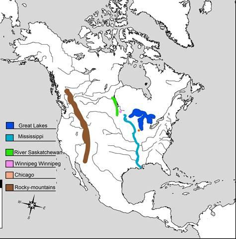
Map skills:
On an outline map of North America, mark the Rocky mountains, the Great Lakes,
River Mississippi, River Saskatchewan, the cities-Chicago and Winnipeg.
Answer
560.7k+ views
Hint:North America is one of two continents of the Americas, named after the Italian wayfarer Amerigo Vespucci, with a surface zone of 24,221,490km² (9,351,969 square miles). It's in the northern side of the equator, between the Pacific Ocean and the Atlantic Ocean and toward the north of South America. North America's most elevated point is Alaska's Denali, which ascends to 6,194m (20,320 ft) above sea level.
Complete answer:
1.The Rocky Mountains: The Rocky Mountains are important for the longest mountain range on the planet. The mountains are composed of many separate reaches. Numerous streams, including the Columbia, Yukon and Colorado wind their ways through the Rockies.
2.The Great Lakes: They are one of the extraordinarily common highlights of the mainland and of the Earth. Aside from Lake Michigan, the lakes give a characteristic fringe among Canada and the United States, outskirts that were balanced out by a boundary-waters treaty of 1909. It is a wellspring of pride for the two nations that there are no fortresses of warships along with the limit.
3.The Mississippi River: The Mississippi River is probably the longest stream on the planet, with a length of around 2,320 miles. The name comes from a Native American name that signifies "enormous waterway". The wellspring of the Mississippi is in the province of Minnesota, close to the outskirts with Canada. It, at that point, streams south through the centre of the USA until it arrives at its mouth in the province of Louisiana, where it at that point streams out into the Gulf of Mexico. The Mississippi has numerous enormous feeder streams that stream into it which cover and channel a large part of the USA.
4.The Saskatchewan River: Its name is derived from the Cree word kisiskâciwanisîpiy meaning quick streaming waterway. The Saskatchewan River was a significant transportation course for First Nations for a large number of years and was an instrumental transportation and asset passage during the hidden exchange and early European exploration.
5.Chicago: Chicago formally the City of Chicago, is the most crowded city in the U.S. territory of Illinois, and the third most crowded city in the United States. With an expected population of 2,693,976 out of 2019, the second most crowded province in the U.S.
6. Winnipeg: Winnipeg is the capital and biggest city in the area of Manitoba in Canada. The city is named after the close by Lake Winnipeg. Known as the "Doorway toward the West", Winnipeg is a railroad and transportation centre with a broadened economy.
Note:The Mississippi River is a progression of huge interconnected freshwater lakes in the upper mid-east area of North America that associate with the Atlantic Ocean through the Saint Lawrence River. Saskatchewan's geological focus lies between Montreal Lake and Lac La Ronge, east of Prince Albert National Park. The city of Chicago is situated in northern Illinois, United States, at the southwestern tip of Lake Michigan.
Recently Updated Pages
Master Class 11 Computer Science: Engaging Questions & Answers for Success
Master Class 11 Business Studies: Engaging Questions & Answers for Success
Master Class 11 Economics: Engaging Questions & Answers for Success
Master Class 11 English: Engaging Questions & Answers for Success
Master Class 11 Maths: Engaging Questions & Answers for Success
Master Class 11 Biology: Engaging Questions & Answers for Success
Trending doubts
One Metric ton is equal to kg A 10000 B 1000 C 100 class 11 physics CBSE
There are 720 permutations of the digits 1 2 3 4 5 class 11 maths CBSE
Discuss the various forms of bacteria class 11 biology CBSE
Draw a diagram of a plant cell and label at least eight class 11 biology CBSE
State the laws of reflection of light
Explain zero factorial class 11 maths CBSE