


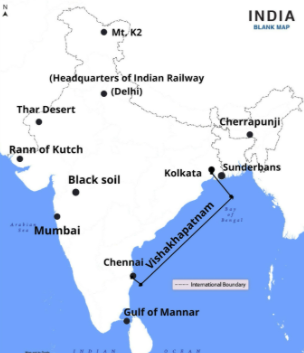
Mark any 10 places/regions on the given outline map of India.
1. Mt.k2
2. Gulf of munnar
3. Western coastal plain
4. Visakhapatnam
5. Cherrapunji
6. The headquarters of Indian railways
7. One tea growing area
8. Rann of Kutch
9. River kaveri
10. thar desert
11. Black soil area
12. Sundarbans
13. Andaman and nicobar islands
14. Mumbai
15. Waterways from Mumbai to Chennai
Answer
526.5k+ views
Hint: The administrative borders of India's states and union territories are represented on the outline map of India. India is a republic with 28 states and eight union territories that make up the region.
Complete answer:
Note: The country's thirteen major ports manage a significant amount of container and freight traffic. The ports of Mumbai, Kandla, Mangalore, JNPT, Mormugao, and Cochin are situated on the west coast. The ports of Chennai, Tuticorin, Visakhapatnam, Paradip, Kolkata, and Ennore are situated on the east coast.
It has a land boundary of 15,200 km (9,445 mi) and a 7,516.6 km coastline (4,671 mi). India is bordered on the south by the Indian Ocean, which includes the Arabian Sea on the west, the Lakshadweep Sea on the southwest, the Bay of Bengal on the east, and the Indian Ocean itself.
India is home to some of the world's highest mountain ranges and mountain routes. Seven major mountain ranges in India have peaks that reach 1000 metres. The Himalayan range is India's most prominent and highest mountain range.
Recently Updated Pages
Master Class 10 Computer Science: Engaging Questions & Answers for Success
Master Class 10 General Knowledge: Engaging Questions & Answers for Success
Master Class 10 English: Engaging Questions & Answers for Success
Master Class 10 Social Science: Engaging Questions & Answers for Success
Master Class 10 Maths: Engaging Questions & Answers for Success
Master Class 10 Science: Engaging Questions & Answers for Success
Trending doubts
What is the median of the first 10 natural numbers class 10 maths CBSE
Which women's tennis player has 24 Grand Slam singles titles?
Who is the Brand Ambassador of Incredible India?
Why is there a time difference of about 5 hours between class 10 social science CBSE
Write a letter to the principal requesting him to grant class 10 english CBSE
A moving boat is observed from the top of a 150 m high class 10 maths CBSE