Courses
Courses for Kids
Free study material
Offline Centres
More
Store Icon
Store

NCERT Solutions for Class 6 Social Science Chapter 1 Locating Places On Earth

ffImage
widget title icon
Latest Updates

Social Science CBSE Class 6 Chapter 1 - FREE PDF Download

Chapter 1: Locating Places on Earth introduces students to the fundamental concepts of geography, focusing on how to locate and identify places on Earth. This chapter covers essential topics such as maps, globes, coordinates, and the use of different tools to pinpoint locations. It emphasizes understanding geographical features and how to use spatial references to navigate the world effectively.

toc-symbol
Table of Content
1. Social Science CBSE Class 6 Chapter 1 - FREE PDF Download
2. Glance on Class 6 Social Science Chapter 1 - Locating Places on Earth
3. Access NCERT Solutions for Class 6 Science Chapter 1 - Locating Places on Earth
    3.1Questions, Activities and Projects (Pg 24)
4. Benefits of NCERT Solutions for Class 6 Social Science Ch 1 - Locating Places on Earth:
5. Important Study Material Links for English Chapter 1 Class 6 
6. Conclusion
7. Chapter-wise NCERT Solutions Class 6 Social Science 
8. Related Important Links for Class 6 Social Science 
FAQs


Our Class 6 Social Science NCERT Solutions PDF provides simplified explanations and interactive activities to help students grasp these concepts with ease. By engaging with this chapter, students will not only learn how to locate places but also develop a keen understanding of geographical tools and their applications. Explore the revised CBSE Class 6 Social Science Syllabus and start practising with the comprehensive exercises provided.


Glance on Class 6 Social Science Chapter 1 - Locating Places on Earth

  • Explains the basic tools used for locating places, including maps and globes, highlighting their importance in understanding Earth’s geography.

  • Describes various types of maps such as political, physical, and thematic maps, and their specific uses in representing different features of the Earth.

  • Covers how to read and interpret maps, including understanding map symbols, legends, and scales to accurately locate places.

  • Introduces the coordinate system used to pinpoint locations on Earth, explaining the concepts of latitude (horizontal lines) and longitude (vertical lines).

  • Teaches how to use latitude and longitude coordinates to locate specific places on a map or globe.

  • Discusses real-life applications of locating places, such as navigation, travel, and understanding global positioning.

  • Emphasizes the significance of maps and globes in learning about and navigating the world, and their role in geography education.

Access NCERT Solutions for Class 6 Science Chapter 1 - Locating Places on Earth

1. What is a map and how do we use it? What are its main components? 

Ans. Map is a representation or drawing of an area of the Earth on a fiat surface whether small or large – say of a district or village or very large area like India or even the world at a specific scale.

Types of Maps:

Physical Maps: Depict the natural features of the Earth, including mountains, oceans, rivers, plains, and plateaus.

Political Maps: Show the political layout of the Earth, including countries, states, borders, capitals, cities, and villages.

Thematic Maps: Provide detailed information on specific topics such as rainfall, forests, minerals, roads, industries, and population density.

Key Elements of Maps: 

Include distance, direction, and symbols.


2. What are coordinates? How can latitude and longitude be used to mark any location on the Earth?

Ans. Coordinates consist of two numbers or sometimes a combination of a letter and a number (like on a chessboard) that pinpoint a specific location on a grid. On a map, latitudes and longitudes serve as these coordinates. They create a systematic grid system that allows for the representation, location, and identification of various Earth features.

Latitudes are horizontal lines measuring distance north and south of the equator, while longitudes are vertical lines measuring distance east and west of the Prime Meridian. There is only one point where these lines intersect. By combining the coordinates of latitude and longitude, one can accurately pinpoint any location on Earth.


3. How are local time and standard time related to longitude?

Ans. Longitudes and Time Calculation: Longitudes help in calculating local and standard time based on Earth’s rotation.

Earth’s Rotation: The Earth rotates from west to east, completing a 360° turn in 24 hours, which equals 15° per hour or 4 minutes per degree of longitude.

Time Zones: The Earth is divided into 24 time zones, each representing a one-hour difference, with zones every 15° east or west of the Prime Meridian.

Local Time Variation: Places east of the Prime Meridian experience sunrise earlier than those to the west, due to the Earth's rotation.

Standard Time: Countries set a central meridian as the standard meridian, creating time zones around it (typically 15° or 7.5° apart). This standard time is uniform within the country.

Example of Standard Time: India uses the 82½° E meridian as its standard meridian, called Indian Standard Time (IST), which is 5 hours and 30 minutes ahead of Greenwich Mean Time (GMT).

Difference between Local and Standard Time: Local time changes with longitude, while standard time remains constant within a country, ensuring consistency.


Questions, Activities and Projects (Pg 24)

1. Returning to page 10 and to Fig. 5.2 in Chapter 5 of this textbook, taking the scale to be 2.5 cm = 500 km, calculate the real distance from the estuary of the Narmada River to the estuary of the Ganga river. (Hint: round off your measurement on the map to an easy number.)

Ans. The distance between the estuaries of the Narmada and Ganga rivers is measured as 10 cm. If 2.5 cm on the map represents 500 km on the ground, then 10 cm corresponds to 4 times that distance, resulting in a total of 2,000 km.


2. Why is it 5:30 pm in India when it is 12 pm or noon in London?

Ans. It is 5:30 pm in India when it is 12:00 pm (noon) in London because:


London lies at 0° longitude, known as the Prime Meridian. India's standard time is based on the 82.5°E longitude, which is the standard meridian for Indian Standard Time (IST). Since India is east of London, the time in India is ahead. The time difference is calculated as 4 minutes per degree of longitude eastward.


Therefore, for India: 82.5° ÷ 1° = 330 minutes difference. 330 minutes equals 5 hours and 30 minutes.


3. Why do we need symbols and colours in the map?

Ans. Symbols and colours play a crucial role in maps because:

It’s not feasible to represent the actual shapes and sizes of features like buildings, roads, temples, rivers, and mountains on a map due to limited space. Instead, symbols and colours are used to represent these features. This allows a large amount of detail and information to be conveyed within a small area.


These symbols and colours make maps easier to understand for a wide range of users and overcome language barriers, as they form a universal language. Known as conventional symbols, they have been standardized for India's maps by the Survey of India, a government authority.


4. Find out what you have in the eight directions from your home or school. 

Ans. 

The location I'm taking for this is my home

North - Supermarket

North East - Stationery

North West - Cafe

East - Apartment

West - Restaurant

South East - Bungalow

South - School

South West - Playground


5. What is the difference between local time and standard time? Discuss it in groups, with each group writing an answer in 100 to 150 words. Compare the answers.

Ans. Local time refers to the time based on the position of the sun in a specific place. It varies from one location to another depending on the longitude. As the Earth rotates, different places experience noon at different times, leading to differences in local time across regions.


Standard time, on the other hand, is the uniform time set for an entire country or region, usually based on the time at a central meridian. It helps avoid confusion caused by having different local times in different areas. For instance, India follows Indian Standard Time (IST), which is based on the 82.5°E longitude.


In summary, while local time varies with each place’s longitude, standard time creates consistency across larger areas, simplifying schedules and activities across cities or countries.


6. Delhi’s and Bengaluru’s latitudes are 29°N and 13°N; their longitudes are almost the same, 77°E. How much will be the difference in local time between the two cities?

Ans. Since Delhi and Bengaluru have nearly the same longitude (77°E), there will be no significant difference in local time based on longitude. Local time is affected by the difference in longitudes, not latitudes. Since both cities lie on the same meridian, the local time between Delhi and Bengaluru will be virtually the same, with any minor differences being negligible.


Latitude affects climate and daylight hours but does not influence local time. Therefore, in this case, despite the difference in latitudes (29°N for Delhi and 13°N for Bengaluru), the local time will remain almost identical because both cities are situated at the same longitude.


7. Mark the following statements as true or false; explain your answers with a sentence or two.

  1. All parallels of latitude have the same length.

Ans. False. Parallels of latitude vary in length, with the Equator being the longest and the lengths decreasing as we move towards the poles.


  1. The length of a meridian of longitude is half of that of the Equator.

Ans. False. The length of a meridian of longitude is the same as the distance around the Earth from pole to pole, whereas the Equator is a full circle around the Earth.


  1. The South Pole has a latitude of 90°S.

Ans. True. The South Pole is located at the southernmost point of the Earth, which corresponds to 90°S latitude.


  1. In Assam, the local time and the IST are identical.

Ans. False. Assam is located further east of the Indian Standard Time (IST) meridian, so the local time in Assam is ahead of IST by a few minutes.


  1. Lines separating the time zones are identical with meridians of longitude.

Ans. False. Although time zones are based on meridians of longitude, the lines separating time zones are often adjusted for political or practical reasons, so they don't always follow meridians exactly.


  1. The Equator is also a parallel of latitude.

Ans. True. The Equator is the largest parallel of latitude at 0° and divides the Earth into the Northern and Southern Hemispheres.


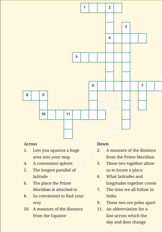
  1. Solve the crossword below


crossword puzzle


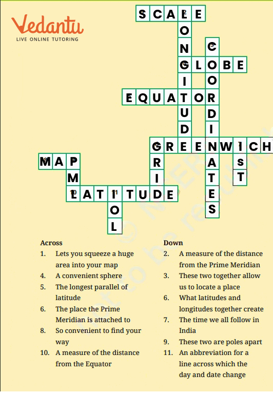
Ans. 


Ans of crossword puzzle


Benefits of NCERT Solutions for Class 6 Social Science Ch 1 - Locating Places on Earth:

  • NCERT solutions provide a simple and clear explanation of topics like latitude, longitude, and time zones, making it easier for students to grasp fundamental geography concepts.

  • The solutions offer precise answers to textbook questions, helping students understand how to frame their responses in exams.

  • Solutions are designed in an engaging way, with examples and diagrams, to enhance students' learning experience.

  • Practicing with NCERT solutions helps students prepare thoroughly for their exams by covering all important points in the chapter.

  • With well-structured solutions, students can manage their study time more efficiently and focus on revising key concepts.

  • Regular practice with these solutions improves students' confidence in handling questions related to locating places on Earth


Important Study Material Links for English Chapter 1 Class 6 

S. No 

Important Study Material Links for Chapter 1

1.

Class 6 Locating Places on Earth Important Questions

2.

Class 6 Locating Places on Earth Revision Notes


Conclusion

Chapter 1 - Locating Places on Earth introduces students to essential geographical concepts like latitudes, longitudes, and the global grid system, helping them understand how to locate places accurately on Earth. These ideas form the foundation of geographic knowledge and play a significant role in understanding time zones and map reading. Vedantu's NCERT Solutions for this chapter are designed to offer clear and detailed explanations of all these concepts, making it easier for students to study and revise. The solutions help students build a strong understanding of the chapter, prepare effectively for exams, and enhance their confidence in solving related questions. With the help of these solutions, students can master the subject in a structured and engaging manner.


Chapter-wise NCERT Solutions Class 6 Social Science 

After familiarising yourself with the Class 6 Social Science Chapter 1 Question Answers, you can access comprehensive NCERT Solutions from all Science Class 6 Science textbook chapters.


Related Important Links for Class 6 Social Science 

Along with this, students can also download additional study materials provided by Vedantu for Social Science Class 6-


FAQs on NCERT Solutions for Class 6 Social Science Chapter 1 Locating Places On Earth

1. What are latitudes and longitudes according to NCERT Solutions Class 6 SST ch 1?

Latitudes are imaginary horizontal lines that run parallel to the Equator, while longitudes are vertical lines that run from the North Pole to the South Pole. These lines help in locating places on Earth.


Vedantu’s NCERT Solutions explain these concepts with simple diagrams and examples to make them easy to understand.

2. Why is the Prime Meridian important?

The Prime Meridian, located at 0° longitude, divides the Earth into the Eastern and Western Hemispheres and is the reference point for time zones worldwide.

3. How are time zones related to longitudes?

Time zones are based on longitudes, with the Earth divided into 24 time zones, each 15° of longitude apart. Each zone represents a one-hour difference in time.

4. What is the significance of the Equator according to NCERT Solutions Class 6 SST ch 1?

The Equator is the most important latitude, dividing the Earth into the Northern and Southern Hemispheres. It is located at 0° latitude.

5. How do symbols and colours help in map reading?

Symbols and colours on a map represent various features like roads, rivers, and mountains. They make maps easier to read and understand.

6. How do latitudes and longitudes help in locating places?

Latitudes and longitudes form a grid system on the Earth’s surface, allowing us to pinpoint exact locations by using the coordinates of these lines.

7. What is the International Date Line (IDL)?

The International Date Line is an imaginary line at 180° longitude, which marks where one calendar day ends, and the next begins.

8. What is meant by the local time of a place?

Local time refers to the time based on the position of the sun at a particular location. It varies depending on the longitude of that place.

9. Why do we need standard time?

Standard time is necessary to have a uniform time across larger regions or countries, as local times can vary significantly due to differences in longitude.

10. What are conventional symbols on a map explained in Social Science Chapter 1: Locating Places on Earth?

Conventional symbols are standard symbols used on maps to represent features such as rivers, mountains, buildings, etc., making map reading easier.

11. What is Indian Standard Time (IST)?

Indian Standard Time (IST) is the time observed across India, based on the 82.5°E longitude. It ensures that the entire country follows the same time.

12. What is the significance of the Tropic of Cancer and Tropic of Capricorn?

The Tropic of Cancer (23.5°N) and the Tropic of Capricorn (23.5°S) are significant latitudes that mark the limits of the tropics, where the sun is directly overhead at least once a year.

13. What is the difference between local time and standard time explained in the Social Science Chapter 1: Locating Places on Earth?

Local time is specific to a location based on its longitude, while standard time is a uniform time used across larger regions or countries.