Which area of the Earth receives maximum sunlight?
A) Polar region
B) Equatorial region
C) Along the latitude of tropic of cancer
D) Along the latitude of tropic of Capricorn
Answer
578.1k+ views
Hint: Polar regions start from the point where the axis line of the Earth’s rotation passes through. The Equatorial region lies between the lines- tropic of cancer and tropic of Capricorn, this also contains the equator line which lies in the center of the earth and directly faces the sun. The region along the tropic of cancer stretches up to the arctic circle, while the region along the tropic of capricorn stretches up to the Antarctic circle.
Complete step by step solution:
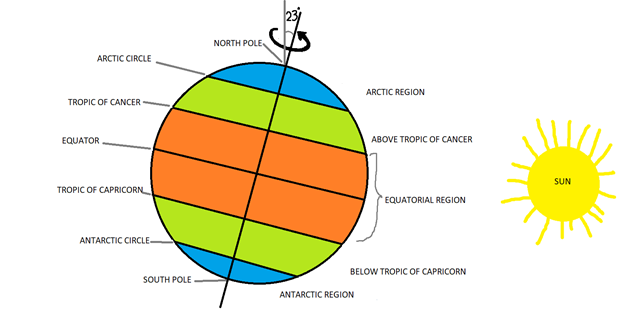
This diagram will give a better understanding of the concept.

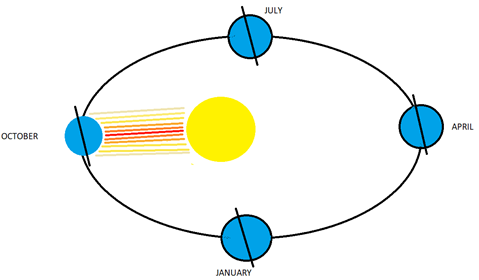
When the Earth revolves around the Sun, It creates a slightly elliptical orbit like this-

All around the year, the Earth is $23.5^\circ $ inclined from vertical relative to this plane.
The earth’s surface is divided into a number of parallel, horizontal, imaginary lines called Latitudes. The location of latitude is specified using the angle which it makes with the central latitude called the Equator line, it is marked as $0^\circ $.
Due to the curved spherical surface of the Earth, the amount of sunlight that reaches a particular latitude is proportional to its cosine.
$I \propto \cos \theta $
Where I is the amount of sun’s light that reaches the area.
And $\theta $ represents the latitude.
This can be useful to calculate the share of sunlight in each area.
Since, $\cos 0^\circ = 1$, sunlight is maximum at the equator.
And, $\cos 90^\circ = 0$, sunlight is minimum at the poles.
So moving from the equator to the poles we find a decrease in the amount of sunlight that falls on earth.
The earth has 3 types of zones-
1. The equatorial zone- Lies between the tropic of cancer ($23^\circ 26'N$) and the tropic of Capricorn ($23^\circ 26'S$).
2. The temperate zone- Lies between the tropic of cancer ($23^\circ 26'N$ ) and arctic circle ($66^\circ 34'N$); and between the tropic of Capricorn ($23^\circ 26'S$) and Antarctic circle ($66^\circ 34'S$).
3. The polar region- Lies between the arctic circle ($66^\circ 34'N$) and the north pole ($90^\circ N$); and between the Antarctic circle ($66^\circ 34'S$) and the south pole ($90^\circ S$).
Since $\cos \theta $ is maximum around the equatorial region, it receives maximum sunlight. Option (B) is correct.
Note: Even if the earth’s axis is inclined, the portion of the Earth which receives maximum sunlight remains on the Equatorial region, because the tropic of cancer and the Capricorn, which act as a borderline between temperate and equatorial region is placed at around $23.5^\circ $, which is the maximum distance which can be reached by equatorial region, which cancels out the inclination of the earth.
Complete step by step solution:
This diagram will give a better understanding of the concept.

When the Earth revolves around the Sun, It creates a slightly elliptical orbit like this-

All around the year, the Earth is $23.5^\circ $ inclined from vertical relative to this plane.
The earth’s surface is divided into a number of parallel, horizontal, imaginary lines called Latitudes. The location of latitude is specified using the angle which it makes with the central latitude called the Equator line, it is marked as $0^\circ $.
Due to the curved spherical surface of the Earth, the amount of sunlight that reaches a particular latitude is proportional to its cosine.
$I \propto \cos \theta $
Where I is the amount of sun’s light that reaches the area.
And $\theta $ represents the latitude.
This can be useful to calculate the share of sunlight in each area.
Since, $\cos 0^\circ = 1$, sunlight is maximum at the equator.
And, $\cos 90^\circ = 0$, sunlight is minimum at the poles.
So moving from the equator to the poles we find a decrease in the amount of sunlight that falls on earth.
The earth has 3 types of zones-
1. The equatorial zone- Lies between the tropic of cancer ($23^\circ 26'N$) and the tropic of Capricorn ($23^\circ 26'S$).
2. The temperate zone- Lies between the tropic of cancer ($23^\circ 26'N$ ) and arctic circle ($66^\circ 34'N$); and between the tropic of Capricorn ($23^\circ 26'S$) and Antarctic circle ($66^\circ 34'S$).
3. The polar region- Lies between the arctic circle ($66^\circ 34'N$) and the north pole ($90^\circ N$); and between the Antarctic circle ($66^\circ 34'S$) and the south pole ($90^\circ S$).
Since $\cos \theta $ is maximum around the equatorial region, it receives maximum sunlight. Option (B) is correct.
Note: Even if the earth’s axis is inclined, the portion of the Earth which receives maximum sunlight remains on the Equatorial region, because the tropic of cancer and the Capricorn, which act as a borderline between temperate and equatorial region is placed at around $23.5^\circ $, which is the maximum distance which can be reached by equatorial region, which cancels out the inclination of the earth.
Recently Updated Pages
Master Class 9 General Knowledge: Engaging Questions & Answers for Success

Master Class 9 Social Science: Engaging Questions & Answers for Success

Master Class 9 English: Engaging Questions & Answers for Success

Master Class 9 Maths: Engaging Questions & Answers for Success

Master Class 9 Science: Engaging Questions & Answers for Success

Class 9 Question and Answer - Your Ultimate Solutions Guide

Trending doubts
Who is eligible for RTE class 9 social science CBSE

What is the Full Form of ISI and RAW

How do you find the valency of chlorine sulphur and class 9 chemistry CBSE

What are the major achievements of the UNO class 9 social science CBSE

Explain the importance of pH in everyday life class 9 chemistry CBSE

Differentiate between parenchyma collenchyma and sclerenchyma class 9 biology CBSE


