Courses
Courses for Kids
Free study material
Offline Centres
More
Store Icon
Store

NCERT Solutions For Class 9 Geography Chapter 3 Drainage

ffImage
widget title icon
Latest Updates

NCERT Class 9 Geography - Chapter 3 Questions and Answers - FREE PDF Download

This free PDF download provides questions and answers for NCERT Class 9 Geography, Chapter 3, "Drainage." The chapter covers the major river systems in India, such as the Ganga, Brahmaputra, and Indus, along with their importance in agriculture and their challenges. Class 9 Geography Chapter 3 NCERT Solutions help you understand these topics clearly, cover all essential points, and prepare effectively for exams. Enhance your studies with Class 9 Geography NCERT Solutions and gain deeper insights into environmental concepts.

toc-symbol
Table of Content
1. NCERT Class 9 Geography - Chapter 3 Questions and Answers - FREE PDF Download
2. Glance on NCERT Solutions for Class 9 Geography (Contemporary India) Chapter 3 Drainage
3. Access NCERT Solutions for Class 9 Geography Chapter - 3 Drainage
4. Topics Covered In Class 9 Geography Chapter 3 Drainage
5. Benefits of NCERT Solutions for Class 9 Social Science Drainage Chapter 3
6. NCERT Solutions for Class 9 Geography - Other Chapter-wise Links for FREE PDF
7. Related Important Links for Class 9 Geography (Contemporary India)
FAQs


By accessing Class 9 Geography Chapter 3 questions and answers, students gain comprehensive insights into the core concepts, such as the drainage system, river patterns, watershed management, and more, as outlined in the curriculum. Download the PDF for easy access to these useful resources. Check out the revised class 9 social science syllabus along with the NCERT Solutions PDF, and start with Vedantu to embark on a journey of academic excellence.


Glance on NCERT Solutions for Class 9 Geography (Contemporary India) Chapter 3 Drainage

  • Class 9th Geography Chapter 3 Drainage explores the drainage system in India, focusing on the river systems and their significance.

  • This Chapter teaches about India's major river systems, including the Himalayan rivers (Indus, Ganga, Brahmaputra) and the Peninsular rivers (Godavari, Krishna, Kaveri, Narmada, Tapi).

  • Understand drainage patterns like dendritic, trellis, radial, and rectangular.

  • Study the concept of river basins and the importance of watershed management.

  • Chapter 3 Drainage Class 9 discusses various types of lakes, their formation processes, and their ecological and economic importance.

  • Utilisation of maps and diagrams to illustrate the courses of major rivers, their tributaries, and drainage patterns, aiding visual learning and retention.

  • Geography class 9, chapter 3 explores issues related to river pollution and the measures taken for water conservation.

  • Drainage class 9 discusses the importance of rivers in agriculture, transportation, and as a water source for domestic and industrial use.

  • Utilise maps to identify and understand the course of major rivers and their tributaries in Chapter 3, Geography class 9.

  • NCERT Class 9 Geography Chapter 3 helps students appreciate the role of rivers and lakes in India's geographical and economic landscape.

Access NCERT Solutions for Class 9 Geography Chapter - 3 Drainage

1. Choose the right answer from the four alternatives given below.

i). In which of the following states is the Wular lake located?

  1. Rajasthan

  2. Uttar Pradesh

  3. Punjab

  4. Jammu and Kashmir

Ans. (d) Jammu and Kashmir

ii). The river Narmada has its source at

  1. Satpura

  2. Brahmagiri

  3. Amarkantak

  4. Slopes of the Western Ghats

Ans. (c) Amarkantak

iii). Which one of the following lakes is a salt water lake?

  1. Sambhar

  2. Dal

  3. Wular

  4. Gobind Sagar

Ans. (a) Sambhar

iv). Which one of the following is the longest river of the Peninsular India?

  1. Narmada

  2. Krishna

  3. Godavari

  4. Mahanadi

Ans. (c) Godavari

v). Which one amongst the following rivers flows through a rift valley?

  1. Mahanadi

  2. Tungabhadra

  3. Krishna

  4. Tapi

Ans. (d) Tapi


2. Answer the following questions briefly.

i). What is meant by a water divide? Give an example.

Ans.  A mountain range or a hill separating two different drainage basins is called a water divide. For example, Western Ghats.

ii). Which is the largest river basin in India?

Ans. The Ganga river basin is the largest river basin in India.

iii). Where do the rivers Indus and Ganga have their origin?

Ans. The Indus river has its origins in Tibet near the Mansarovar Lake while the Ganga River has its origins in the Gangotri Glacier in Uttarakhand state.

iv). Name the two headstreams of the Ganga. Where do they meet to form the Ganga?

Ans. Alaknanda and Bhagirathi are the two headstreams of the Ganga. They both meet to form the Ganga at Devprayag.

v). Why does the Brahmaputra in its Tibetan part have less silt, despite a longer course?

Ans. The Brahmaputra river also known as Tsangpo in Tibet receives very little volume of water in Tibet so it carries little silt there. But once it enters into India from Arunachal Pradesh, it is fed by lots of rains and hence carries lots of water and silt.

vi). Which two Peninsular rivers flow through trough?

Ans. The two rivers that flow through troughs in India are Narmada and Tapi. They form estuaries while entering the sea unlike deltas.

vii). State some economic benefits of rivers and lakes.

Ans. Rivers are very beneficial for agricultural purposes and generating hydro- electricity. They also provide fisheries and inland channels for transportation. The lakes like the Sambhar Lake provide edible salts to people. They also help to develop tourism and provide recreation for people such as Panging Tso.


3. Below are given names of a few lakes of India. Group them under two categories – Natural and created by human beings.

  1. Wular

  2. Dal

  3. Nainital

  4. Bhimtal

  5. Gobind Sagar

  6. Loktak

  7. Barapani

  8. Chilika

  9. Sambhar

  10. Rana Pratap Sagar

  11. Nizam Sagar

  12. Pulicat

  13. Nagarjuna Sagar

  14. Hirakud

Ans. The Natural Lakes are: Wular, Dal, Nainital, Bhimtal, Chilika, Pulicat, Sambhar, Barapani, Loktak.

The Lakes created by human beings are: Gobind Sagar, Hirakud, Rana Pratap Sagar, Nagarjuna Sagar, Nizam Sagar.


4. Discuss the significant difference between the Himalayan and the Peninsular rivers.

Ans. The following is the comparison of the two rivers:

S. No.

Himalayan Rivers

Peninsular Rivers

1

Himalayan rivers are perennial.

Peninsular rivers are seasonal.

2

They are fed by glaciers.

They receive water from the rainfall.

3

The Himalayan rivers are long and deep.

The peninsular rivers are short and shallow.

4

They carry a lot silt and sand.

They carry very no silt.

5

These rivers originate in the Himalayas in northern India.

These rivers originate in the Western Ghats.

6

Their drainage basins are large.

Their drainage basins are small.

7

These rivers form very large deltas.

They form very small or no deltas.


5. Compare the east flowing and the west flowing rivers of the Peninsular plateau.

Ans. The following is the comparison of the two rivers:

S. No.

East Flowing Rivers

West Flowing Rivers

1.

They fall into the Bay of Bengal.

They fall into the Arabian Sea.

2.

They form Estuaries

They form Deltas.

3.

They have a large tributary network.

They have no tributary networks.

4.

They do not flow through troughs.

They flow through troughs.


6. Why are rivers important for the country’s economy?

Ans. The rivers important for the any country’s economy because:

  • They are a source of natural fresh water which is required for the survival of all living beings.

  • The rivers provide water for various purposes as well as act as important trade routes within the country.

  • They also serve as a source of potential energy using hydro power.

  • It is also used for navigation and transportation and is important for commercial activities.

  • It also provides great scenic and recreational values for tourism. Thus, they serve as good tourist spots in the state.


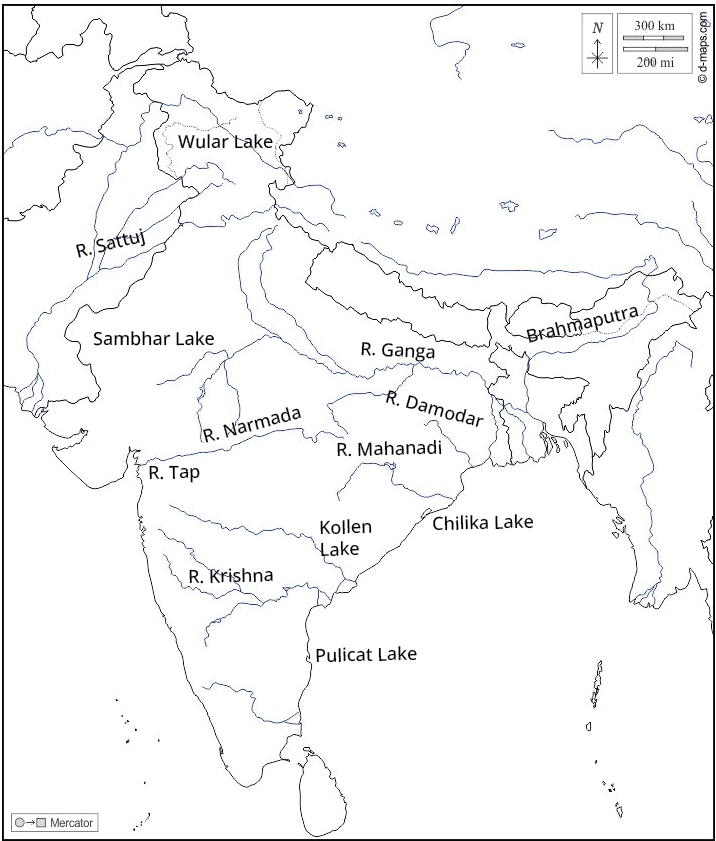
(i) On an outline map of India mark and label the following rivers: Ganga, Satluj, Damodar, Krishna, Narmada, Tapi, Mahanadi, and Brahmaputra.

(ii) On an outline map of India mark and label the following lakes: Chilika Sambhar, Wular, Pulicat, Kolleru.

Ans:

Outline Map of India Mark Lakes


Outline Map of India mark Lakes


Topics Covered In Class 9 Geography Chapter 3 Drainage

Geography Chapter 3 Class 9 Drainage Topics

  1. Drainage system of India

  1. Himalayan rivers

  1. Peninsular rivers, Lakes 

  1. The Role of rivers in the economy 

  1. And River pollution


Benefits of NCERT Solutions for Class 9 Social Science Drainage Chapter 3

  • The NCERT solutions provide detailed explanations of India's drainage system, helping students grasp the complexity of river systems, drainage patterns, and their significance.

  • All the concepts in drainage class 9 question answers are explained in simple language combined with diagrams, discussions, maps, etc, wherever needed. 

  • The solutions provide a clear and comprehensive understanding of the chapter's content, aiding in effective exam preparation.

  • By breaking down intricate topics such as river basins, watershed management, and different types of lakes, the solutions ensure that students clearly understand key geographical concepts.

  • The geography class 9 chapter 3 solutions include maps and diagrams that aid visual learning, making it easier for students to visualise the courses of rivers, their tributaries, and various drainage patterns.

  • By explaining the geographical significance of rivers and lakes in drainage class 9, the solutions help students understand the real-world impact of these water bodies on agriculture, transportation, and human settlements.

  • Vedantu offers the best NCERT Solutions chapter 3 Geography class 9, providing comprehensive support for students' self-study needs.


For better preparation, you can refer to Vedantu’s additional study materials, like Revision Notes for Class 9 Drainage, and Important Questions for Class 9 Drainage along with the NCERT Solutions.  


Conclusion 

NCERT Solutions for Class 9 Geography Chapter 3, "Drainage," offers a comprehensive and in-depth understanding of India's intricate drainage system. These solutions provide detailed explanations of key concepts such as river systems, drainage patterns, and watershed management, making complex topics accessible and understandable for students. Students can rely on Vedantu's NCERT Solutions to enhance their knowledge, clarify doubts, and confidently prepare for exams.


NCERT Solutions for Class 9 Geography - Other Chapter-wise Links for FREE PDF

Dive into our FREE PDF links, which offer chapter-wise NCERT solutions prepared by Vedantu Experts to help you understand and master social concepts.


Related Important Links for Class 9 Geography (Contemporary India)

FAQs on NCERT Solutions For Class 9 Geography Chapter 3 Drainage

1. What are the differences between the East Flowing rivers and the West Flowing rivers?

The differences between the East flowing rivers and the West flowing rivers are given as follows.

  • The East flowing rivers drain in the Bay of Bengal and the West flowing rivers drain in the Arabian Sea.

  • The East flowing rivers carry a lot of sediments whereas the West flowing rivers carry fewer amounts of sediments.

  • The East flowing rivers form deltas at their mouths and the West flowing rivers form estuaries at their mouths.

  • The East flowing rivers have a greater number of tributaries whereas the West flowing rivers have a fewer number of tributaries.

2. How many questions are there in the NCERT Solutions for Class 9 Social Science Contemporary India Chapter-3 Drainage?

There are 6 questions and a map-pointing task in the NCERT Solutions for Class 9 Social Science Contemporary India Chapter-3 Drainage. The first few questions have sub-parts. There are very short answer type questions, short answer type questions, and long answer type questions, in this chapter. You will find solutions for all the questions in this PDF and refer to them to understand the appropriate answer pattern.

3. Give two reasons for which rivers are important for a country’s economy.

The two reasons for which rivers are important for a country’s economy are as follows.

  • The water from the rivers is used in the hydel-power generation and for running hydro-electric dams in a country.

  • The rivers are also used for navigation and transportation, thereby, supporting various commercial activities of a country.

4. Are the NCERT Solutions for Class 9 Social Science Contemporary India Chapter- 3 Drainage reliable study resources?

Yes, the NCERT Solutions for Class 9 Social Science Contemporary India Chapter- 3 Drainage are very reliable study resources. These solutions are prepared by the subject matter experts at Vedantu, in adherence to the NCERT guidelines. These solutions cover all the key points of this chapter, hence by referring to these solutions you will be able to revise all the topics covered in this chapter. Also, the PDF is free to download for all students. So you can rely on these solutions of the NCERT Class 9 SST Chapter-3 for your exam preparation.

5. What is the basic concept of Chapter 3 in the Social Science book? 

Chapter 3 in the Class 9 Social Science book is “Drainage”. It is one of the crucial topics covered in the Class 9 Geography book ‘Contemporary India’. The chapter deals with the drainage system of Indian rivers. Moreover, it also covers other water bodies, drainage systems like Peninsular rivers, Himalayan rivers, pollution in rivers, lakes, islands, and the impact of climate. The chapter also comprises maps and diagrams to draw student’s attention.

6. What is the weightage of Chapter 3 Drainage in Social Science paper? 

Chapter 3 Drainage in Geography Class 9 book is one of those chapters in Social Studies where you can score well. Lots of questions from this chapter are asked in the examination. Therefore, you must read its NCERT Solutions available on Vedantu to have a better outlook of the topic. These are also available on the Vedantu app and they are free of cost. If you read this chapter thoroughly, you’ll be able to score extra marks easily in your Social Science paper.

7. Write the advantages of reading NCERT Solutions for Chapter 3 Drainage. 

There are endless advantages of reading NCERT Solutions of Chapter 3 Drainage from the Class 9 Geography book ‘Contemporary India’. The advantages are - 

  • The NCERT Solutions for this chapter will assist students to get all the missing answers.

  • These solutions will help you solve textbook questions. 

  • They enact the best study material so that students can clarify their doubts. 

  • The NCERT Solutions can also be used as reference materials to write answers to the questions given at the end of this chapter. 

8. Write examples of east flowing rivers in India. 

There are numerous examples of east flowing rivers in India. The Brahmaputra, the Ganga, the Godavari, the Krishna, the Mahanadi, the Vaigai, the Penneru, the Kaveri, the Pannaiyar and the Subarnarekha are some examples of these rivers. All east flowing rivers drain their water in the Bay of Bengal and cover 77% of the area in the Indian drainage system. These rivers have huge catchment areas and form deltas instead of estuaries. 

9. Write examples of west flowing rivers in India. 

The examples of west flowing rivers are the Narmada, the Indus, the Tapi, the Mahi, the Ghaagar, the Sabarmati, the Saravati, the Luni, the Periyar, the Bharat Puja, and the Pumba. The other west flowing rivers on the western coast of India descend from Sahyadris. All the west flowing rivers flow into the Arabian sea. As compared to east flowing rivers, these cover an area of 23% in the drainage system of India and form estuaries besides deltas.

10. What topics are covered in Chapter 3 - Drainage class 9?

Chapter 3 Geography Class 9 covers India's major river systems, different drainage patterns, river basins, types of lakes, water pollution, and conservation measures.

11. How does the NCERT class 9th geography chapter 3 question answer help understand India's drainage system?

The NCERT solutions drainage class 9 question answer provides detailed explanations, maps, diagrams, and real-life examples, making it easier to understand the complex drainage systems and their geographical significance.

12. Why are drainage class 9 question answer patterns important to study?

Class 9 geography chapter 3 question answer patterns help in understanding the geographical features and underlying rock structures of an area. Class 9 Geography Chapter 3 question answer also influences soil fertility, vegetation, and human settlement patterns.

13. What benefits does the NCERT class 9 geography chapter 3 question answer provide for exam preparation?

Class 9 geography chapter 3 questions and answers offer structured answers to textbook questions, practice exercises, and map-based questions, helping students prepare effectively for exams and score well.

14. What is the significance of studying the drainage system in India as discussed in class 9th geography chapter 3 question answer?

Studying the class 9th geography chapter 3 question answer helps us understand the geographical and economic importance of rivers, including their role in irrigation, transportation, and supporting biodiversity.

15. How do the NCERT solutions class 9 geography ch 3 question answer explain the formation of different types of lakes?

The class 9 geography ch 3 question answer provides detailed explanations on the formation of various types of lakes, such as tectonic, glacial, and artificial lakes, along with their significance.

16. How are the NCERT geography class 9 chapter 3 question answers beneficial for competitive exams?

The NCERT geography class 9 chapter 3 question answer provides a strong foundation in geography, which is beneficial for competitive exams that include geography sections, such as UPSC and state-level exams.