


Give some uses of geostationary satellites
Answer
594k+ views
Hint: The uses of the geostationary satellites are harnessed based on its properties. A satellite is said to be geostationary since for an observer observing the satellite on the surface of the earth will find that the satellite is always fixed at the same position i.e. stationary. These satellites are used such that it becomes easy to keep track of different things at any given point of time.
Complete step by step answer:
A geostationary satellite has a time period of revolution of 24 hours i.e. the time taken by the earth to complete one rotation. It is because of this the relative velocity of the satellite and the earth is zero and it appears as if the satellite is stationary. The height of a geostationary satellite if fixed i.e. roughly 35000 kilometers away from the surface of the earth.
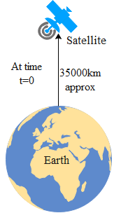
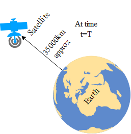
From the above diagram we can see that an observer on the earth will see the satellite at the same position even after time T from t initial as 0.
These satellites are used for communication purposes. This is because the antenas fixed on the earth's surface would not have to revolve in order to detect the signal coming from the satellite. It is because of this fundamental reason broadcasting satellites are also placed in the geostationary orbit so that the antennas of the television are permanently pointed to the sky.
These satellites are also used for taking infrared photos of the same place for years in order to study the variation. The Navigation satellites are also placed in this region for proper GPS accuracy.
Note:
There cannot be an infinite number of satellites which can be geostationary since the circumference of the geostationary orbit is fixed. The geostationary satellites are positioned differently in the geostationary orbits. Hence at a time we can get the photos of the entire surface of the earth for a given moment of time.
Complete step by step answer:
A geostationary satellite has a time period of revolution of 24 hours i.e. the time taken by the earth to complete one rotation. It is because of this the relative velocity of the satellite and the earth is zero and it appears as if the satellite is stationary. The height of a geostationary satellite if fixed i.e. roughly 35000 kilometers away from the surface of the earth.
From the above diagram we can see that an observer on the earth will see the satellite at the same position even after time T from t initial as 0.
These satellites are used for communication purposes. This is because the antenas fixed on the earth's surface would not have to revolve in order to detect the signal coming from the satellite. It is because of this fundamental reason broadcasting satellites are also placed in the geostationary orbit so that the antennas of the television are permanently pointed to the sky.
These satellites are also used for taking infrared photos of the same place for years in order to study the variation. The Navigation satellites are also placed in this region for proper GPS accuracy.
Note:
There cannot be an infinite number of satellites which can be geostationary since the circumference of the geostationary orbit is fixed. The geostationary satellites are positioned differently in the geostationary orbits. Hence at a time we can get the photos of the entire surface of the earth for a given moment of time.
Recently Updated Pages
Master Class 12 Economics: Engaging Questions & Answers for Success
Master Class 12 Physics: Engaging Questions & Answers for Success
Master Class 12 English: Engaging Questions & Answers for Success
Master Class 12 Social Science: Engaging Questions & Answers for Success
Master Class 12 Maths: Engaging Questions & Answers for Success
Master Class 12 Business Studies: Engaging Questions & Answers for Success
Trending doubts
Which are the Top 10 Largest Countries of the World?
What are the major means of transport Explain each class 12 social science CBSE
Draw a labelled sketch of the human eye class 12 physics CBSE
Why cannot DNA pass through cell membranes class 12 biology CBSE
Differentiate between insitu conservation and exsitu class 12 biology CBSE
Draw a neat and well labeled diagram of TS of ovary class 12 biology CBSE